Olduvai Formation 3 - The Tectonic History of Africa
Why has East Africa been such a productive place to look for evidence of
early hominids? The answer to that question lies in the geological history of
Africa. There are two general conditions necessary for the discovery of very
old fossils of land animals. The first is that the animals have to inhabit an
area where rapid deposition, preferably by very fine grained materials, occurs.
Moreover, that deposition has to occur over a long period of time. The second
is that eventually erosion must expose the lowest strata so that the fossils can
be detected by human observers. The tectonic and geological history of Africa
has provided both of these conditions in the Rift Valleys of East Africa, where
many of the earliest fossil remains of humans and their tools have been
discovered.

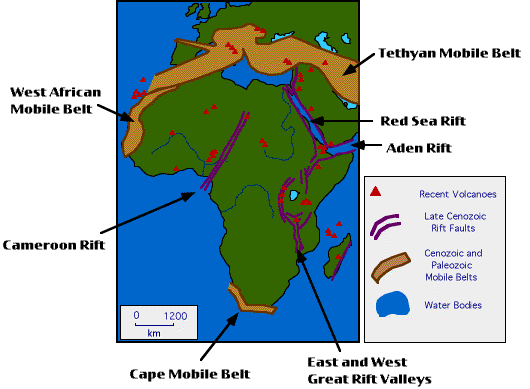
Map of Africa and Adjacent Eurasia Showing Important Geophysical Features.
Features are described below.
-
CAMEROON RIFT
- The Cameroon Rift is an extremely long and straight rift valley dating to
the Cenozoic Era (65-0 million years ago). Its formation resulted in
substantial volcanic activity in west and central Africa. The rift was caused
by severe warping and uplifting of the craton (as much as 2,000 meters). The
uplifting caused expansion of the crust and the resultant collapse of the arch
crests along normal faults. The collapse formed the rift valley, and the breaks
in the crust along the fault lines allowed magma to escape near the surface,
causing increased volcanism. The rift is continued off of the Afro-Arabian
Craton by a 2500 km long sub-oceanic ridge, the Guinea Ridge, that terminates
at St. Helena Island. It is possible that continued continental shifting may
extend the rift as far north as the Mediterranean Sea, effectively splitting
West Africa from Central Africa.
WEST AFRICAN MOBILE BELT
- The West African Mobile Belt is a Cenozoic relict area where materials
eroded from the Afro-Arabian Craton were deposited at the western continental
margin. Much of this area was later uplifted by continental displacement. The
Mobile Belt may have at one time been coterminous with the mobile belt along the
eastern margin of North America that eventually gave rise to the Appalachian
Mountains. The Belt dates to the Late Paleozoic (500-230 million years ago).
CAPE MOBILE BELT
- The Cape Mobile Belt is a Cenozoic relict area where materials eroded from
the Afro-Arabian Craton were deposited at the southern continental margin. Much
of this area was later uplifted by continental displacement. This Mobile Belt
was probably never coterminous with any of the other land masses of the period.
The Belt dates to the Late Paleozoic (500-230 million years ago).
TETHYAN MOBILE BELT
- The Tethyan Mobile Belt actually extends from this area, across northern
India, through the Himalaya Mountain Range, and finally terminates in the
vicinity of Indonesia. This Mobile Belt was formed as the result of the
deposition of erosional materials from the Afro-Arabian craton, the European
craton, the Ural-Mongolian Mobile Belt, the Chinese craton, and the Indian
craton. The belt dates to the Late Mesozoic-Early Cenozoic eras (100-25 million
years ago). As you can see, most of the current landmass of southern Europe is
built from this material.
RED SEA RIFT
- The Red Sea Rift began during the Miocene Epoch (about 25 million years
ago) and continues today. Its formation is related to the formation of the Aden
Rift. The two rifts have now effectively separated Africa from Arabia, although
the two were once part of the same landmass, the Afro-Arabian craton. It has
been suggested that the rifting was caused by Africa being displaced 200
kilometers south and west of its original position. Both Rifts attain oceanic
depths (i.e. 2,000 meters below sea level) over most of their extent. It is
possible that Africa is actually pivoting away from Arabia.
ADEN RIFT
- The Aden Rift began during the Miocene Epoch (about 25 million years ago)
and continues today. Its formation is related to the formation of the Red Sea
Rift. The two rifts have now effectively separated Africa from Arabia, although
the two were once part of the same landmass, the Afro-Arabian craton. It has
been suggested that the rifting was caused by Africa being displaced 200
kilometers south and west of its original position. Both Rifts attain oceanic
depths (i.e. 2,000 meters below sea level) over most of their extent. It is
possible that Africa is actually pivoting away from Arabia.
EAST AND WEST GREAT RIFT VALLEYS
- The East and West Great Rift Valleys of East Africa offer some of the
richest beds of fossils dating from the Miocene and younger to be found in the
world. With the exception of the South African cave deposits, all of the most
important type fossils for Australopithecus and early Homo have been found
within the Rift zone. The rifts were caused by severe warping and uplifting of
the craton (as much as 2,000 meters). The uplifting caused expansion of the
crust and the resultant collapse of the arch crests along normal faults. The
collapse formed the rift valleys, and the breaks in the crust along the fault
lines allowed magma to escape near the surface, causing increased volcanism.
The rifts began forming during the Miocene Epoch (65 million years ago).
![[Prev Page]](../../images/Btns/PrevBtn.gif)
|
|
![[Next Page]](../../images/Btns/NextBtn.gif)
|
|
|

